Warning: [snuffleupagus][0.0.0.0][config][log] It seems that you are filtering on a parameter 'var_array' of the function 'extract', but the parameter does not exists. in /home/jotarobl/public_html/wp-includes/template.php on line 795
Warning: [snuffleupagus][0.0.0.0][config][log] - 0 parameter's name: 'array' in /home/jotarobl/public_html/wp-includes/template.php on line 795
Warning: [snuffleupagus][0.0.0.0][config][log] - 1 parameter's name: 'flags' in /home/jotarobl/public_html/wp-includes/template.php on line 795
Warning: [snuffleupagus][0.0.0.0][config][log] - 2 parameter's name: 'prefix' in /home/jotarobl/public_html/wp-includes/template.php on line 795
Warning: [snuffleupagus][0.0.0.0][config][log] It seems that you are filtering on a parameter 'extract_type' of the function 'extract', but the parameter does not exists. in /home/jotarobl/public_html/wp-includes/template.php on line 795
Warning: [snuffleupagus][0.0.0.0][config][log] - 0 parameter's name: 'array' in /home/jotarobl/public_html/wp-includes/template.php on line 795
Warning: [snuffleupagus][0.0.0.0][config][log] - 1 parameter's name: 'flags' in /home/jotarobl/public_html/wp-includes/template.php on line 795
Warning: [snuffleupagus][0.0.0.0][config][log] - 2 parameter's name: 'prefix' in /home/jotarobl/public_html/wp-includes/template.php on line 795
Warning: [snuffleupagus][0.0.0.0][config][log] It seems that you are filtering on a parameter 'var_array' of the function 'extract', but the parameter does not exists. in /home/jotarobl/public_html/wp-includes/template.php on line 795
Warning: [snuffleupagus][0.0.0.0][config][log] - 0 parameter's name: 'array' in /home/jotarobl/public_html/wp-includes/template.php on line 795
Warning: [snuffleupagus][0.0.0.0][config][log] - 1 parameter's name: 'flags' in /home/jotarobl/public_html/wp-includes/template.php on line 795
Warning: [snuffleupagus][0.0.0.0][config][log] - 2 parameter's name: 'prefix' in /home/jotarobl/public_html/wp-includes/template.php on line 795
Warning: [snuffleupagus][0.0.0.0][config][log] It seems that you are filtering on a parameter 'extract_type' of the function 'extract', but the parameter does not exists. in /home/jotarobl/public_html/wp-includes/template.php on line 795
Warning: [snuffleupagus][0.0.0.0][config][log] - 0 parameter's name: 'array' in /home/jotarobl/public_html/wp-includes/template.php on line 795
Warning: [snuffleupagus][0.0.0.0][config][log] - 1 parameter's name: 'flags' in /home/jotarobl/public_html/wp-includes/template.php on line 795
Warning: [snuffleupagus][0.0.0.0][config][log] - 2 parameter's name: 'prefix' in /home/jotarobl/public_html/wp-includes/template.php on line 795 Proyecto de Grado Final: “Pa’ Donde? A.U.” – Jota Robles Warning: [snuffleupagus][0.0.0.0][config][log] It seems that you are filtering on a parameter 'var_array' of the function 'extract', but the parameter does not exists. in /home/jotarobl/public_html/wp-content/themes/dt-the7/inc/class-the7-template-manager.php on line 43
Warning: [snuffleupagus][0.0.0.0][config][log] - 0 parameter's name: 'array' in /home/jotarobl/public_html/wp-content/themes/dt-the7/inc/class-the7-template-manager.php on line 43
Warning: [snuffleupagus][0.0.0.0][config][log] - 1 parameter's name: 'flags' in /home/jotarobl/public_html/wp-content/themes/dt-the7/inc/class-the7-template-manager.php on line 43
Warning: [snuffleupagus][0.0.0.0][config][log] - 2 parameter's name: 'prefix' in /home/jotarobl/public_html/wp-content/themes/dt-the7/inc/class-the7-template-manager.php on line 43
Warning: [snuffleupagus][0.0.0.0][config][log] It seems that you are filtering on a parameter 'extract_type' of the function 'extract', but the parameter does not exists. in /home/jotarobl/public_html/wp-content/themes/dt-the7/inc/class-the7-template-manager.php on line 43
Warning: [snuffleupagus][0.0.0.0][config][log] - 0 parameter's name: 'array' in /home/jotarobl/public_html/wp-content/themes/dt-the7/inc/class-the7-template-manager.php on line 43
Warning: [snuffleupagus][0.0.0.0][config][log] - 1 parameter's name: 'flags' in /home/jotarobl/public_html/wp-content/themes/dt-the7/inc/class-the7-template-manager.php on line 43
Warning: [snuffleupagus][0.0.0.0][config][log] - 2 parameter's name: 'prefix' in /home/jotarobl/public_html/wp-content/themes/dt-the7/inc/class-the7-template-manager.php on line 43
Warning: [snuffleupagus][0.0.0.0][config][log] It seems that you are filtering on a parameter 'var_array' of the function 'extract', but the parameter does not exists. in /home/jotarobl/public_html/wp-content/themes/dt-the7/inc/class-the7-template-manager.php on line 46
Warning: [snuffleupagus][0.0.0.0][config][log] - 0 parameter's name: 'array' in /home/jotarobl/public_html/wp-content/themes/dt-the7/inc/class-the7-template-manager.php on line 46
Warning: [snuffleupagus][0.0.0.0][config][log] - 1 parameter's name: 'flags' in /home/jotarobl/public_html/wp-content/themes/dt-the7/inc/class-the7-template-manager.php on line 46
Warning: [snuffleupagus][0.0.0.0][config][log] - 2 parameter's name: 'prefix' in /home/jotarobl/public_html/wp-content/themes/dt-the7/inc/class-the7-template-manager.php on line 46
Warning: [snuffleupagus][0.0.0.0][config][log] It seems that you are filtering on a parameter 'extract_type' of the function 'extract', but the parameter does not exists. in /home/jotarobl/public_html/wp-content/themes/dt-the7/inc/class-the7-template-manager.php on line 46
Warning: [snuffleupagus][0.0.0.0][config][log] - 0 parameter's name: 'array' in /home/jotarobl/public_html/wp-content/themes/dt-the7/inc/class-the7-template-manager.php on line 46
Warning: [snuffleupagus][0.0.0.0][config][log] - 1 parameter's name: 'flags' in /home/jotarobl/public_html/wp-content/themes/dt-the7/inc/class-the7-template-manager.php on line 46
Warning: [snuffleupagus][0.0.0.0][config][log] - 2 parameter's name: 'prefix' in /home/jotarobl/public_html/wp-content/themes/dt-the7/inc/class-the7-template-manager.php on line 46
Warning: [snuffleupagus][0.0.0.0][config][log] It seems that you are filtering on a parameter 'var_array' of the function 'extract', but the parameter does not exists. in /home/jotarobl/public_html/wp-content/themes/dt-the7/inc/class-the7-template-manager.php on line 43
Warning: [snuffleupagus][0.0.0.0][config][log] - 0 parameter's name: 'array' in /home/jotarobl/public_html/wp-content/themes/dt-the7/inc/class-the7-template-manager.php on line 43
Warning: [snuffleupagus][0.0.0.0][config][log] - 1 parameter's name: 'flags' in /home/jotarobl/public_html/wp-content/themes/dt-the7/inc/class-the7-template-manager.php on line 43
Warning: [snuffleupagus][0.0.0.0][config][log] - 2 parameter's name: 'prefix' in /home/jotarobl/public_html/wp-content/themes/dt-the7/inc/class-the7-template-manager.php on line 43
Warning: [snuffleupagus][0.0.0.0][config][log] It seems that you are filtering on a parameter 'extract_type' of the function 'extract', but the parameter does not exists. in /home/jotarobl/public_html/wp-content/themes/dt-the7/inc/class-the7-template-manager.php on line 43
Warning: [snuffleupagus][0.0.0.0][config][log] - 0 parameter's name: 'array' in /home/jotarobl/public_html/wp-content/themes/dt-the7/inc/class-the7-template-manager.php on line 43
Warning: [snuffleupagus][0.0.0.0][config][log] - 1 parameter's name: 'flags' in /home/jotarobl/public_html/wp-content/themes/dt-the7/inc/class-the7-template-manager.php on line 43
Warning: [snuffleupagus][0.0.0.0][config][log] - 2 parameter's name: 'prefix' in /home/jotarobl/public_html/wp-content/themes/dt-the7/inc/class-the7-template-manager.php on line 43
Warning: [snuffleupagus][0.0.0.0][config][log] It seems that you are filtering on a parameter 'var_array' of the function 'extract', but the parameter does not exists. in /home/jotarobl/public_html/wp-content/themes/dt-the7/inc/class-the7-template-manager.php on line 46
Warning: [snuffleupagus][0.0.0.0][config][log] - 0 parameter's name: 'array' in /home/jotarobl/public_html/wp-content/themes/dt-the7/inc/class-the7-template-manager.php on line 46
Warning: [snuffleupagus][0.0.0.0][config][log] - 1 parameter's name: 'flags' in /home/jotarobl/public_html/wp-content/themes/dt-the7/inc/class-the7-template-manager.php on line 46
Warning: [snuffleupagus][0.0.0.0][config][log] - 2 parameter's name: 'prefix' in /home/jotarobl/public_html/wp-content/themes/dt-the7/inc/class-the7-template-manager.php on line 46
Warning: [snuffleupagus][0.0.0.0][config][log] It seems that you are filtering on a parameter 'extract_type' of the function 'extract', but the parameter does not exists. in /home/jotarobl/public_html/wp-content/themes/dt-the7/inc/class-the7-template-manager.php on line 46
Warning: [snuffleupagus][0.0.0.0][config][log] - 0 parameter's name: 'array' in /home/jotarobl/public_html/wp-content/themes/dt-the7/inc/class-the7-template-manager.php on line 46
Warning: [snuffleupagus][0.0.0.0][config][log] - 1 parameter's name: 'flags' in /home/jotarobl/public_html/wp-content/themes/dt-the7/inc/class-the7-template-manager.php on line 46
Warning: [snuffleupagus][0.0.0.0][config][log] - 2 parameter's name: 'prefix' in /home/jotarobl/public_html/wp-content/themes/dt-the7/inc/class-the7-template-manager.php on line 46
Skip to content Warning: [snuffleupagus][0.0.0.0][config][log] It seems that you are filtering on a parameter 'var_array' of the function 'extract', but the parameter does not exists. in /home/jotarobl/public_html/wp-content/themes/dt-the7/inc/class-the7-template-manager.php on line 43
Warning: [snuffleupagus][0.0.0.0][config][log] - 0 parameter's name: 'array' in /home/jotarobl/public_html/wp-content/themes/dt-the7/inc/class-the7-template-manager.php on line 43
Warning: [snuffleupagus][0.0.0.0][config][log] - 1 parameter's name: 'flags' in /home/jotarobl/public_html/wp-content/themes/dt-the7/inc/class-the7-template-manager.php on line 43
Warning: [snuffleupagus][0.0.0.0][config][log] - 2 parameter's name: 'prefix' in /home/jotarobl/public_html/wp-content/themes/dt-the7/inc/class-the7-template-manager.php on line 43
Warning: [snuffleupagus][0.0.0.0][config][log] It seems that you are filtering on a parameter 'extract_type' of the function 'extract', but the parameter does not exists. in /home/jotarobl/public_html/wp-content/themes/dt-the7/inc/class-the7-template-manager.php on line 43
Warning: [snuffleupagus][0.0.0.0][config][log] - 0 parameter's name: 'array' in /home/jotarobl/public_html/wp-content/themes/dt-the7/inc/class-the7-template-manager.php on line 43
Warning: [snuffleupagus][0.0.0.0][config][log] - 1 parameter's name: 'flags' in /home/jotarobl/public_html/wp-content/themes/dt-the7/inc/class-the7-template-manager.php on line 43
Warning: [snuffleupagus][0.0.0.0][config][log] - 2 parameter's name: 'prefix' in /home/jotarobl/public_html/wp-content/themes/dt-the7/inc/class-the7-template-manager.php on line 43
Warning: [snuffleupagus][0.0.0.0][config][log] It seems that you are filtering on a parameter 'var_array' of the function 'extract', but the parameter does not exists. in /home/jotarobl/public_html/wp-content/themes/dt-the7/inc/class-the7-template-manager.php on line 46
Warning: [snuffleupagus][0.0.0.0][config][log] - 0 parameter's name: 'array' in /home/jotarobl/public_html/wp-content/themes/dt-the7/inc/class-the7-template-manager.php on line 46
Warning: [snuffleupagus][0.0.0.0][config][log] - 1 parameter's name: 'flags' in /home/jotarobl/public_html/wp-content/themes/dt-the7/inc/class-the7-template-manager.php on line 46
Warning: [snuffleupagus][0.0.0.0][config][log] - 2 parameter's name: 'prefix' in /home/jotarobl/public_html/wp-content/themes/dt-the7/inc/class-the7-template-manager.php on line 46
Warning: [snuffleupagus][0.0.0.0][config][log] It seems that you are filtering on a parameter 'extract_type' of the function 'extract', but the parameter does not exists. in /home/jotarobl/public_html/wp-content/themes/dt-the7/inc/class-the7-template-manager.php on line 46
Warning: [snuffleupagus][0.0.0.0][config][log] - 0 parameter's name: 'array' in /home/jotarobl/public_html/wp-content/themes/dt-the7/inc/class-the7-template-manager.php on line 46
Warning: [snuffleupagus][0.0.0.0][config][log] - 1 parameter's name: 'flags' in /home/jotarobl/public_html/wp-content/themes/dt-the7/inc/class-the7-template-manager.php on line 46
Warning: [snuffleupagus][0.0.0.0][config][log] - 2 parameter's name: 'prefix' in /home/jotarobl/public_html/wp-content/themes/dt-the7/inc/class-the7-template-manager.php on line 46
Warning: [snuffleupagus][0.0.0.0][config][log] It seems that you are filtering on a parameter 'var_array' of the function 'extract', but the parameter does not exists. in /home/jotarobl/public_html/wp-content/themes/dt-the7/inc/class-the7-template-manager.php on line 43
Warning: [snuffleupagus][0.0.0.0][config][log] - 0 parameter's name: 'array' in /home/jotarobl/public_html/wp-content/themes/dt-the7/inc/class-the7-template-manager.php on line 43
Warning: [snuffleupagus][0.0.0.0][config][log] - 1 parameter's name: 'flags' in /home/jotarobl/public_html/wp-content/themes/dt-the7/inc/class-the7-template-manager.php on line 43
Warning: [snuffleupagus][0.0.0.0][config][log] - 2 parameter's name: 'prefix' in /home/jotarobl/public_html/wp-content/themes/dt-the7/inc/class-the7-template-manager.php on line 43
Warning: [snuffleupagus][0.0.0.0][config][log] It seems that you are filtering on a parameter 'extract_type' of the function 'extract', but the parameter does not exists. in /home/jotarobl/public_html/wp-content/themes/dt-the7/inc/class-the7-template-manager.php on line 43
Warning: [snuffleupagus][0.0.0.0][config][log] - 0 parameter's name: 'array' in /home/jotarobl/public_html/wp-content/themes/dt-the7/inc/class-the7-template-manager.php on line 43
Warning: [snuffleupagus][0.0.0.0][config][log] - 1 parameter's name: 'flags' in /home/jotarobl/public_html/wp-content/themes/dt-the7/inc/class-the7-template-manager.php on line 43
Warning: [snuffleupagus][0.0.0.0][config][log] - 2 parameter's name: 'prefix' in /home/jotarobl/public_html/wp-content/themes/dt-the7/inc/class-the7-template-manager.php on line 43
Warning: [snuffleupagus][0.0.0.0][config][log] It seems that you are filtering on a parameter 'var_array' of the function 'extract', but the parameter does not exists. in /home/jotarobl/public_html/wp-content/themes/dt-the7/inc/class-the7-template-manager.php on line 46
Warning: [snuffleupagus][0.0.0.0][config][log] - 0 parameter's name: 'array' in /home/jotarobl/public_html/wp-content/themes/dt-the7/inc/class-the7-template-manager.php on line 46
Warning: [snuffleupagus][0.0.0.0][config][log] - 1 parameter's name: 'flags' in /home/jotarobl/public_html/wp-content/themes/dt-the7/inc/class-the7-template-manager.php on line 46
Warning: [snuffleupagus][0.0.0.0][config][log] - 2 parameter's name: 'prefix' in /home/jotarobl/public_html/wp-content/themes/dt-the7/inc/class-the7-template-manager.php on line 46
Warning: [snuffleupagus][0.0.0.0][config][log] It seems that you are filtering on a parameter 'extract_type' of the function 'extract', but the parameter does not exists. in /home/jotarobl/public_html/wp-content/themes/dt-the7/inc/class-the7-template-manager.php on line 46
Warning: [snuffleupagus][0.0.0.0][config][log] - 0 parameter's name: 'array' in /home/jotarobl/public_html/wp-content/themes/dt-the7/inc/class-the7-template-manager.php on line 46
Warning: [snuffleupagus][0.0.0.0][config][log] - 1 parameter's name: 'flags' in /home/jotarobl/public_html/wp-content/themes/dt-the7/inc/class-the7-template-manager.php on line 46
Warning: [snuffleupagus][0.0.0.0][config][log] - 2 parameter's name: 'prefix' in /home/jotarobl/public_html/wp-content/themes/dt-the7/inc/class-the7-template-manager.php on line 46
Jota Robles
Warning: [snuffleupagus][0.0.0.0][config][log] It seems that you are filtering on a parameter 'var_array' of the function 'extract', but the parameter does not exists. in /home/jotarobl/public_html/wp-content/themes/dt-the7/inc/class-the7-template-manager.php on line 43
Warning: [snuffleupagus][0.0.0.0][config][log] - 0 parameter's name: 'array' in /home/jotarobl/public_html/wp-content/themes/dt-the7/inc/class-the7-template-manager.php on line 43
Warning: [snuffleupagus][0.0.0.0][config][log] - 1 parameter's name: 'flags' in /home/jotarobl/public_html/wp-content/themes/dt-the7/inc/class-the7-template-manager.php on line 43
Warning: [snuffleupagus][0.0.0.0][config][log] - 2 parameter's name: 'prefix' in /home/jotarobl/public_html/wp-content/themes/dt-the7/inc/class-the7-template-manager.php on line 43
Warning: [snuffleupagus][0.0.0.0][config][log] It seems that you are filtering on a parameter 'extract_type' of the function 'extract', but the parameter does not exists. in /home/jotarobl/public_html/wp-content/themes/dt-the7/inc/class-the7-template-manager.php on line 43
Warning: [snuffleupagus][0.0.0.0][config][log] - 0 parameter's name: 'array' in /home/jotarobl/public_html/wp-content/themes/dt-the7/inc/class-the7-template-manager.php on line 43
Warning: [snuffleupagus][0.0.0.0][config][log] - 1 parameter's name: 'flags' in /home/jotarobl/public_html/wp-content/themes/dt-the7/inc/class-the7-template-manager.php on line 43
Warning: [snuffleupagus][0.0.0.0][config][log] - 2 parameter's name: 'prefix' in /home/jotarobl/public_html/wp-content/themes/dt-the7/inc/class-the7-template-manager.php on line 43
Warning: [snuffleupagus][0.0.0.0][config][log] It seems that you are filtering on a parameter 'var_array' of the function 'extract', but the parameter does not exists. in /home/jotarobl/public_html/wp-content/themes/dt-the7/inc/class-the7-template-manager.php on line 46
Warning: [snuffleupagus][0.0.0.0][config][log] - 0 parameter's name: 'array' in /home/jotarobl/public_html/wp-content/themes/dt-the7/inc/class-the7-template-manager.php on line 46
Warning: [snuffleupagus][0.0.0.0][config][log] - 1 parameter's name: 'flags' in /home/jotarobl/public_html/wp-content/themes/dt-the7/inc/class-the7-template-manager.php on line 46
Warning: [snuffleupagus][0.0.0.0][config][log] - 2 parameter's name: 'prefix' in /home/jotarobl/public_html/wp-content/themes/dt-the7/inc/class-the7-template-manager.php on line 46
Warning: [snuffleupagus][0.0.0.0][config][log] It seems that you are filtering on a parameter 'extract_type' of the function 'extract', but the parameter does not exists. in /home/jotarobl/public_html/wp-content/themes/dt-the7/inc/class-the7-template-manager.php on line 46
Warning: [snuffleupagus][0.0.0.0][config][log] - 0 parameter's name: 'array' in /home/jotarobl/public_html/wp-content/themes/dt-the7/inc/class-the7-template-manager.php on line 46
Warning: [snuffleupagus][0.0.0.0][config][log] - 1 parameter's name: 'flags' in /home/jotarobl/public_html/wp-content/themes/dt-the7/inc/class-the7-template-manager.php on line 46
Warning: [snuffleupagus][0.0.0.0][config][log] - 2 parameter's name: 'prefix' in /home/jotarobl/public_html/wp-content/themes/dt-the7/inc/class-the7-template-manager.php on line 46
Warning: [snuffleupagus][0.0.0.0][config][log] It seems that you are filtering on a parameter 'var_array' of the function 'extract', but the parameter does not exists. in /home/jotarobl/public_html/wp-includes/template.php on line 795
Warning: [snuffleupagus][0.0.0.0][config][log] - 0 parameter's name: 'array' in /home/jotarobl/public_html/wp-includes/template.php on line 795
Warning: [snuffleupagus][0.0.0.0][config][log] - 1 parameter's name: 'flags' in /home/jotarobl/public_html/wp-includes/template.php on line 795
Warning: [snuffleupagus][0.0.0.0][config][log] - 2 parameter's name: 'prefix' in /home/jotarobl/public_html/wp-includes/template.php on line 795
Warning: [snuffleupagus][0.0.0.0][config][log] It seems that you are filtering on a parameter 'extract_type' of the function 'extract', but the parameter does not exists. in /home/jotarobl/public_html/wp-includes/template.php on line 795
Warning: [snuffleupagus][0.0.0.0][config][log] - 0 parameter's name: 'array' in /home/jotarobl/public_html/wp-includes/template.php on line 795
Warning: [snuffleupagus][0.0.0.0][config][log] - 1 parameter's name: 'flags' in /home/jotarobl/public_html/wp-includes/template.php on line 795
Warning: [snuffleupagus][0.0.0.0][config][log] - 2 parameter's name: 'prefix' in /home/jotarobl/public_html/wp-includes/template.php on line 795
Warning: [snuffleupagus][0.0.0.0][config][log] It seems that you are filtering on a parameter 'var_array' of the function 'extract', but the parameter does not exists. in /home/jotarobl/public_html/wp-content/themes/dt-the7/inc/helpers/post-navigation.php on line 232
Warning: [snuffleupagus][0.0.0.0][config][log] - 0 parameter's name: 'array' in /home/jotarobl/public_html/wp-content/themes/dt-the7/inc/helpers/post-navigation.php on line 232
Warning: [snuffleupagus][0.0.0.0][config][log] - 1 parameter's name: 'flags' in /home/jotarobl/public_html/wp-content/themes/dt-the7/inc/helpers/post-navigation.php on line 232
Warning: [snuffleupagus][0.0.0.0][config][log] - 2 parameter's name: 'prefix' in /home/jotarobl/public_html/wp-content/themes/dt-the7/inc/helpers/post-navigation.php on line 232
Warning: [snuffleupagus][0.0.0.0][config][log] It seems that you are filtering on a parameter 'extract_type' of the function 'extract', but the parameter does not exists. in /home/jotarobl/public_html/wp-content/themes/dt-the7/inc/helpers/post-navigation.php on line 232
Warning: [snuffleupagus][0.0.0.0][config][log] - 0 parameter's name: 'array' in /home/jotarobl/public_html/wp-content/themes/dt-the7/inc/helpers/post-navigation.php on line 232
Warning: [snuffleupagus][0.0.0.0][config][log] - 1 parameter's name: 'flags' in /home/jotarobl/public_html/wp-content/themes/dt-the7/inc/helpers/post-navigation.php on line 232
Warning: [snuffleupagus][0.0.0.0][config][log] - 2 parameter's name: 'prefix' in /home/jotarobl/public_html/wp-content/themes/dt-the7/inc/helpers/post-navigation.php on line 232
Warning: [snuffleupagus][0.0.0.0][config][log] It seems that you are filtering on a parameter 'var_array' of the function 'extract', but the parameter does not exists. in /home/jotarobl/public_html/wp-includes/template.php on line 795
Warning: [snuffleupagus][0.0.0.0][config][log] - 0 parameter's name: 'array' in /home/jotarobl/public_html/wp-includes/template.php on line 795
Warning: [snuffleupagus][0.0.0.0][config][log] - 1 parameter's name: 'flags' in /home/jotarobl/public_html/wp-includes/template.php on line 795
Warning: [snuffleupagus][0.0.0.0][config][log] - 2 parameter's name: 'prefix' in /home/jotarobl/public_html/wp-includes/template.php on line 795
Warning: [snuffleupagus][0.0.0.0][config][log] It seems that you are filtering on a parameter 'extract_type' of the function 'extract', but the parameter does not exists. in /home/jotarobl/public_html/wp-includes/template.php on line 795
Warning: [snuffleupagus][0.0.0.0][config][log] - 0 parameter's name: 'array' in /home/jotarobl/public_html/wp-includes/template.php on line 795
Warning: [snuffleupagus][0.0.0.0][config][log] - 1 parameter's name: 'flags' in /home/jotarobl/public_html/wp-includes/template.php on line 795
Warning: [snuffleupagus][0.0.0.0][config][log] - 2 parameter's name: 'prefix' in /home/jotarobl/public_html/wp-includes/template.php on line 795 Warning: [snuffleupagus][0.0.0.0][config][log] It seems that you are filtering on a parameter 'var_array' of the function 'extract', but the parameter does not exists. in /home/jotarobl/public_html/wp-content/themes/dt-the7/inc/class-the7-template-manager.php on line 43
Warning: [snuffleupagus][0.0.0.0][config][log] - 0 parameter's name: 'array' in /home/jotarobl/public_html/wp-content/themes/dt-the7/inc/class-the7-template-manager.php on line 43
Warning: [snuffleupagus][0.0.0.0][config][log] - 1 parameter's name: 'flags' in /home/jotarobl/public_html/wp-content/themes/dt-the7/inc/class-the7-template-manager.php on line 43
Warning: [snuffleupagus][0.0.0.0][config][log] - 2 parameter's name: 'prefix' in /home/jotarobl/public_html/wp-content/themes/dt-the7/inc/class-the7-template-manager.php on line 43
Warning: [snuffleupagus][0.0.0.0][config][log] It seems that you are filtering on a parameter 'extract_type' of the function 'extract', but the parameter does not exists. in /home/jotarobl/public_html/wp-content/themes/dt-the7/inc/class-the7-template-manager.php on line 43
Warning: [snuffleupagus][0.0.0.0][config][log] - 0 parameter's name: 'array' in /home/jotarobl/public_html/wp-content/themes/dt-the7/inc/class-the7-template-manager.php on line 43
Warning: [snuffleupagus][0.0.0.0][config][log] - 1 parameter's name: 'flags' in /home/jotarobl/public_html/wp-content/themes/dt-the7/inc/class-the7-template-manager.php on line 43
Warning: [snuffleupagus][0.0.0.0][config][log] - 2 parameter's name: 'prefix' in /home/jotarobl/public_html/wp-content/themes/dt-the7/inc/class-the7-template-manager.php on line 43
Warning: [snuffleupagus][0.0.0.0][config][log] It seems that you are filtering on a parameter 'var_array' of the function 'extract', but the parameter does not exists. in /home/jotarobl/public_html/wp-content/themes/dt-the7/inc/class-the7-template-manager.php on line 46
Warning: [snuffleupagus][0.0.0.0][config][log] - 0 parameter's name: 'array' in /home/jotarobl/public_html/wp-content/themes/dt-the7/inc/class-the7-template-manager.php on line 46
Warning: [snuffleupagus][0.0.0.0][config][log] - 1 parameter's name: 'flags' in /home/jotarobl/public_html/wp-content/themes/dt-the7/inc/class-the7-template-manager.php on line 46
Warning: [snuffleupagus][0.0.0.0][config][log] - 2 parameter's name: 'prefix' in /home/jotarobl/public_html/wp-content/themes/dt-the7/inc/class-the7-template-manager.php on line 46
Warning: [snuffleupagus][0.0.0.0][config][log] It seems that you are filtering on a parameter 'extract_type' of the function 'extract', but the parameter does not exists. in /home/jotarobl/public_html/wp-content/themes/dt-the7/inc/class-the7-template-manager.php on line 46
Warning: [snuffleupagus][0.0.0.0][config][log] - 0 parameter's name: 'array' in /home/jotarobl/public_html/wp-content/themes/dt-the7/inc/class-the7-template-manager.php on line 46
Warning: [snuffleupagus][0.0.0.0][config][log] - 1 parameter's name: 'flags' in /home/jotarobl/public_html/wp-content/themes/dt-the7/inc/class-the7-template-manager.php on line 46
Warning: [snuffleupagus][0.0.0.0][config][log] - 2 parameter's name: 'prefix' in /home/jotarobl/public_html/wp-content/themes/dt-the7/inc/class-the7-template-manager.php on line 46
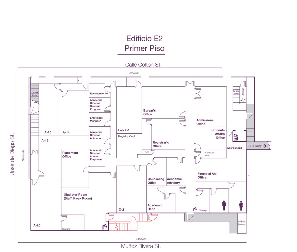
This Project was created by two former master’s students, Martin Merlo a programmer who created the code and designed the interface, and me José J. Robles a graphic designer who in this project focused on cleaning the maps given by the university of their campus for the use of the project, the indicators inside of the map.
This Project was focused on helping out students at the university to have a database they can use to reach their desired locations.
In the image above we can see floor map that was used on the video, what was worked on here was removing and cleaning up elements that were a hindrance for the database’s ability to work as reliable as it can be. Many more maps were developed for future updates but for the sake of the university’s privacy it will be hidden.
This image above is an example of one of the routes and created for the project. the gladiator icon indicates the location of the destination. The imagery and colors chosen were to be attuned with the identity of the university as their mascot is a gladiator and color schemes that were on their print media website.
This icon was meant to be used for a future version of the project where it would be used as thumbnail to the “app” that would have been able to be downloaded on service apps like google play, etc.
Warning: [snuffleupagus][0.0.0.0][config][log] It seems that you are filtering on a parameter 'var_array' of the function 'extract', but the parameter does not exists. in /home/jotarobl/public_html/wp-content/themes/dt-the7/inc/class-the7-template-manager.php on line 43
Warning: [snuffleupagus][0.0.0.0][config][log] - 0 parameter's name: 'array' in /home/jotarobl/public_html/wp-content/themes/dt-the7/inc/class-the7-template-manager.php on line 43
Warning: [snuffleupagus][0.0.0.0][config][log] - 1 parameter's name: 'flags' in /home/jotarobl/public_html/wp-content/themes/dt-the7/inc/class-the7-template-manager.php on line 43
Warning: [snuffleupagus][0.0.0.0][config][log] - 2 parameter's name: 'prefix' in /home/jotarobl/public_html/wp-content/themes/dt-the7/inc/class-the7-template-manager.php on line 43
Warning: [snuffleupagus][0.0.0.0][config][log] It seems that you are filtering on a parameter 'extract_type' of the function 'extract', but the parameter does not exists. in /home/jotarobl/public_html/wp-content/themes/dt-the7/inc/class-the7-template-manager.php on line 43
Warning: [snuffleupagus][0.0.0.0][config][log] - 0 parameter's name: 'array' in /home/jotarobl/public_html/wp-content/themes/dt-the7/inc/class-the7-template-manager.php on line 43
Warning: [snuffleupagus][0.0.0.0][config][log] - 1 parameter's name: 'flags' in /home/jotarobl/public_html/wp-content/themes/dt-the7/inc/class-the7-template-manager.php on line 43
Warning: [snuffleupagus][0.0.0.0][config][log] - 2 parameter's name: 'prefix' in /home/jotarobl/public_html/wp-content/themes/dt-the7/inc/class-the7-template-manager.php on line 43
Warning: [snuffleupagus][0.0.0.0][config][log] It seems that you are filtering on a parameter 'var_array' of the function 'extract', but the parameter does not exists. in /home/jotarobl/public_html/wp-content/themes/dt-the7/inc/class-the7-template-manager.php on line 46
Warning: [snuffleupagus][0.0.0.0][config][log] - 0 parameter's name: 'array' in /home/jotarobl/public_html/wp-content/themes/dt-the7/inc/class-the7-template-manager.php on line 46
Warning: [snuffleupagus][0.0.0.0][config][log] - 1 parameter's name: 'flags' in /home/jotarobl/public_html/wp-content/themes/dt-the7/inc/class-the7-template-manager.php on line 46
Warning: [snuffleupagus][0.0.0.0][config][log] - 2 parameter's name: 'prefix' in /home/jotarobl/public_html/wp-content/themes/dt-the7/inc/class-the7-template-manager.php on line 46
Warning: [snuffleupagus][0.0.0.0][config][log] It seems that you are filtering on a parameter 'extract_type' of the function 'extract', but the parameter does not exists. in /home/jotarobl/public_html/wp-content/themes/dt-the7/inc/class-the7-template-manager.php on line 46
Warning: [snuffleupagus][0.0.0.0][config][log] - 0 parameter's name: 'array' in /home/jotarobl/public_html/wp-content/themes/dt-the7/inc/class-the7-template-manager.php on line 46
Warning: [snuffleupagus][0.0.0.0][config][log] - 1 parameter's name: 'flags' in /home/jotarobl/public_html/wp-content/themes/dt-the7/inc/class-the7-template-manager.php on line 46
Warning: [snuffleupagus][0.0.0.0][config][log] - 2 parameter's name: 'prefix' in /home/jotarobl/public_html/wp-content/themes/dt-the7/inc/class-the7-template-manager.php on line 46 Warning: [snuffleupagus][0.0.0.0][config][log] It seems that you are filtering on a parameter 'var_array' of the function 'extract', but the parameter does not exists. in /home/jotarobl/public_html/wp-content/themes/dt-the7/inc/class-the7-template-manager.php on line 43
Warning: [snuffleupagus][0.0.0.0][config][log] - 0 parameter's name: 'array' in /home/jotarobl/public_html/wp-content/themes/dt-the7/inc/class-the7-template-manager.php on line 43
Warning: [snuffleupagus][0.0.0.0][config][log] - 1 parameter's name: 'flags' in /home/jotarobl/public_html/wp-content/themes/dt-the7/inc/class-the7-template-manager.php on line 43
Warning: [snuffleupagus][0.0.0.0][config][log] - 2 parameter's name: 'prefix' in /home/jotarobl/public_html/wp-content/themes/dt-the7/inc/class-the7-template-manager.php on line 43
Warning: [snuffleupagus][0.0.0.0][config][log] It seems that you are filtering on a parameter 'extract_type' of the function 'extract', but the parameter does not exists. in /home/jotarobl/public_html/wp-content/themes/dt-the7/inc/class-the7-template-manager.php on line 43
Warning: [snuffleupagus][0.0.0.0][config][log] - 0 parameter's name: 'array' in /home/jotarobl/public_html/wp-content/themes/dt-the7/inc/class-the7-template-manager.php on line 43
Warning: [snuffleupagus][0.0.0.0][config][log] - 1 parameter's name: 'flags' in /home/jotarobl/public_html/wp-content/themes/dt-the7/inc/class-the7-template-manager.php on line 43
Warning: [snuffleupagus][0.0.0.0][config][log] - 2 parameter's name: 'prefix' in /home/jotarobl/public_html/wp-content/themes/dt-the7/inc/class-the7-template-manager.php on line 43
Warning: [snuffleupagus][0.0.0.0][config][log] It seems that you are filtering on a parameter 'var_array' of the function 'extract', but the parameter does not exists. in /home/jotarobl/public_html/wp-content/themes/dt-the7/inc/class-the7-template-manager.php on line 46
Warning: [snuffleupagus][0.0.0.0][config][log] - 0 parameter's name: 'array' in /home/jotarobl/public_html/wp-content/themes/dt-the7/inc/class-the7-template-manager.php on line 46
Warning: [snuffleupagus][0.0.0.0][config][log] - 1 parameter's name: 'flags' in /home/jotarobl/public_html/wp-content/themes/dt-the7/inc/class-the7-template-manager.php on line 46
Warning: [snuffleupagus][0.0.0.0][config][log] - 2 parameter's name: 'prefix' in /home/jotarobl/public_html/wp-content/themes/dt-the7/inc/class-the7-template-manager.php on line 46
Warning: [snuffleupagus][0.0.0.0][config][log] It seems that you are filtering on a parameter 'extract_type' of the function 'extract', but the parameter does not exists. in /home/jotarobl/public_html/wp-content/themes/dt-the7/inc/class-the7-template-manager.php on line 46
Warning: [snuffleupagus][0.0.0.0][config][log] - 0 parameter's name: 'array' in /home/jotarobl/public_html/wp-content/themes/dt-the7/inc/class-the7-template-manager.php on line 46
Warning: [snuffleupagus][0.0.0.0][config][log] - 1 parameter's name: 'flags' in /home/jotarobl/public_html/wp-content/themes/dt-the7/inc/class-the7-template-manager.php on line 46
Warning: [snuffleupagus][0.0.0.0][config][log] - 2 parameter's name: 'prefix' in /home/jotarobl/public_html/wp-content/themes/dt-the7/inc/class-the7-template-manager.php on line 46
Warning: [snuffleupagus][0.0.0.0][config][log] It seems that you are filtering on a parameter 'var_array' of the function 'extract', but the parameter does not exists. in /home/jotarobl/public_html/wp-includes/template.php on line 795
Warning: [snuffleupagus][0.0.0.0][config][log] - 0 parameter's name: 'array' in /home/jotarobl/public_html/wp-includes/template.php on line 795
Warning: [snuffleupagus][0.0.0.0][config][log] - 1 parameter's name: 'flags' in /home/jotarobl/public_html/wp-includes/template.php on line 795
Warning: [snuffleupagus][0.0.0.0][config][log] - 2 parameter's name: 'prefix' in /home/jotarobl/public_html/wp-includes/template.php on line 795
Warning: [snuffleupagus][0.0.0.0][config][log] It seems that you are filtering on a parameter 'extract_type' of the function 'extract', but the parameter does not exists. in /home/jotarobl/public_html/wp-includes/template.php on line 795
Warning: [snuffleupagus][0.0.0.0][config][log] - 0 parameter's name: 'array' in /home/jotarobl/public_html/wp-includes/template.php on line 795
Warning: [snuffleupagus][0.0.0.0][config][log] - 1 parameter's name: 'flags' in /home/jotarobl/public_html/wp-includes/template.php on line 795
Warning: [snuffleupagus][0.0.0.0][config][log] - 2 parameter's name: 'prefix' in /home/jotarobl/public_html/wp-includes/template.php on line 795
Warning: [snuffleupagus][0.0.0.0][config][log] It seems that you are filtering on a parameter 'var_array' of the function 'extract', but the parameter does not exists. in /home/jotarobl/public_html/wp-includes/template.php on line 795
Warning: [snuffleupagus][0.0.0.0][config][log] - 0 parameter's name: 'array' in /home/jotarobl/public_html/wp-includes/template.php on line 795
Warning: [snuffleupagus][0.0.0.0][config][log] - 1 parameter's name: 'flags' in /home/jotarobl/public_html/wp-includes/template.php on line 795
Warning: [snuffleupagus][0.0.0.0][config][log] - 2 parameter's name: 'prefix' in /home/jotarobl/public_html/wp-includes/template.php on line 795
Warning: [snuffleupagus][0.0.0.0][config][log] It seems that you are filtering on a parameter 'extract_type' of the function 'extract', but the parameter does not exists. in /home/jotarobl/public_html/wp-includes/template.php on line 795
Warning: [snuffleupagus][0.0.0.0][config][log] - 0 parameter's name: 'array' in /home/jotarobl/public_html/wp-includes/template.php on line 795
Warning: [snuffleupagus][0.0.0.0][config][log] - 1 parameter's name: 'flags' in /home/jotarobl/public_html/wp-includes/template.php on line 795
Warning: [snuffleupagus][0.0.0.0][config][log] - 2 parameter's name: 'prefix' in /home/jotarobl/public_html/wp-includes/template.php on line 795 Go to Top


